Our Vision: Burnaby is a green and inclusive city with safe and connected neighbourhoods and a vibrant economy where people want to live, work and play for generations to come
The Burnaby 2050 Official Community Plan (OCP) was adopted in December 2025 and will guide the development of Burnaby for the next 25 years.
Our OCP presents a long-term vision for the community. It provides the strategic direction, framework and guidance to meet the anticipated needs of the community while ensuring Burnaby is a desirable place to live, work and invest in the future.
Burnaby 2050 Official Community Plan
The Burnaby 2050 OCP is structured around a central guiding vision that was chosen by the community:
“Burnaby is a green and inclusive city with safe and connected neighbourhoods and a vibrant economy where people want to live, work and play for generations to come.”
And guided by the community’s values:

The OCP integrates land use, transportation, housing, the environment, community facilities and services, and social and economic planning into a broad strategy to direct the growth and development of the city. It is contemporary and considerate of emerging trends, issues, challenges and opportunities, particularly in areas of housing affordability, climate change and adaptation. The plan was developed with the community to ensure that Burnaby grows in a way that reflects the aspirations and values of the community.
Read the Official Community Plan
Community engagement
The Burnaby 2050 OCP is the culmination of a multi-year, multi-phase process that engaged people, organizations, Host Nations, and regional authorities.
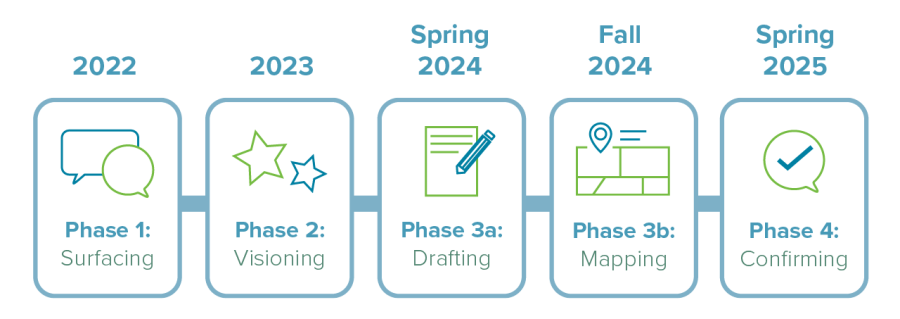
We met thousands of community members at our 61 events, workshops, and meetings; received 3,656 responses to our surveys; and reviewed over 23,090 comments. The contributions of community members and stakeholders helped make Burnaby 2050 a better plan and one that truly reflects our shared vision for Burnaby.
Read our What We Heard Reports
A living document–amending the Official Community Plan
The Burnaby 2050 OCP is a living document that may be amended to address the community’s evolving needs. Subject to the requirements of the Local Government Act, the OCP will be reviewed and updated every five years. Amendments can also be pursued at any time, including changes to land use designations or the policy framework to accommodate development or new policy directions. Property owners may also apply for an amendment to the OCP (process for which is set out in the Development Procedures Bylaw).
The plan at a glance
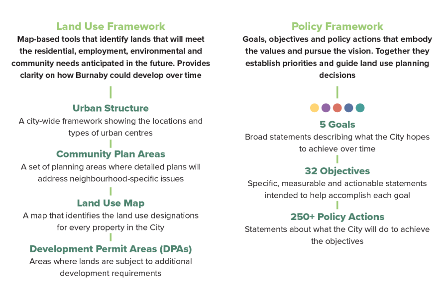
Land Use Framework
The Land Use Framework guides development to meet Burnaby’s anticipated residential, employment, environmental and community needs. It also aligns infrastructure, utilities and transportation planning with future development, ensuring that services are planned in coordination with land use and growth.
The Burnaby 2050 OCP employs a parcel-based land use map which means each lot in the city is assigned a specific land use designation.
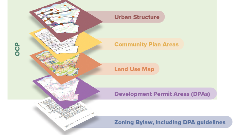
Land Use Map
Land Use Designations are different categories that outline the future intended land uses for each parcel in the city, over the long term. Each land use designation on the OCP Land Use Map corresponds to a zoning district in the Burnaby Zoning Bylaw. The Zoning Bylaw specifies the permitted uses, height and setbacks and other regulations for each zoning district.
Base and Overlay Designations
Some sites have two land use designations:
- The base land use designation is shown as a solid colour covering the parcel.
- The overlay land use designation is shown as a coloured outline around the parcel. The overlay designation provides additional or alternate uses on a property.
- Refer to Table 2. Permitted Uses on Sites with Overlay Designations (p.51) for more information about the rules around each Base-Overlay combination.
Community Plan Areas
Burnaby is organized into 20 Community Plan Areas, each with one or more distinct urban centres and its own Community Plan. Community Plans complement and support the objectives of the OCP, while providing more detail specific to the area.
Where the land use designations in a Community Plan and the OCP are not consistent, the designation in the OCP prevails. Learn more about Burnaby's Community Plans.
Development Permit Areas
With the adoption of Burnaby 2050, the City is introducing Development Permit Areas (DPAs). These are geographic areas where development proposals are reviewed against the applicable DPA Guidelines prior to the issuance of a development permit. The Local Government Act allows municipalities to create DPAs and Guidelines to support a variety of land use goals such as the regulation of form and character of development and environmental protection.
The City of Burnaby has Development Permit Areas and associated guidelines for:
In the future, the City may create additional DPAs including a Natural Hazard DPA.
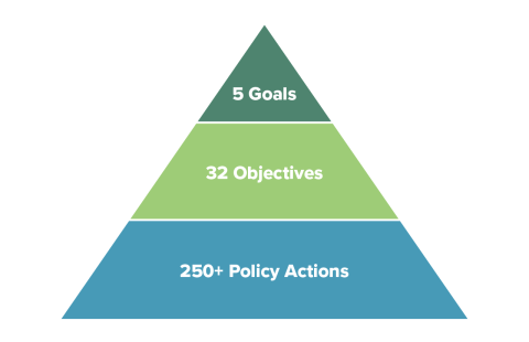
Policy Framework
The policy framework includes 5 goals, 32 objectives and 250+ policy actions. These policies guide the City’s implementation of the OCP’s vision.
Foster complete communities that are sustainable, equitable and accessible to everyone (page: 62-76).
- Objectives:
- 1.1: Concentrate growth in complete communities
- 1.2: Provide a range of housing choices to meet the needs of all residents
- 1.3: Maintain and create community facilities and services to meet the needs of a growing and diverse population
- 1.4: Provide quality parks and open spaces through protection, planning and programming
- 1.5: Protect and strengthen food systems to support healthy communities
- 1.6: Promote convenience within and between neighbourhoods
Create welcoming public spaces, cultural opportunities and a sense of belonging for all (page: 77-90).
- Objectives:
- 2.1: Create inclusive public spaces that are accessible and respond to everyday needs
- 2.2: Integrate arts, heritage and other aspects of Burnaby’s cultural identity into the fabric of daily life, creating a vibrant community for all
- 2.3: Raise the visibility of Host Nations’ connections to the land and resources, while supporting access to places of cultural significance
- 2.4: Encourage placemaking by recognizing the histories of diverse communities
- 2.5: Create processes that strengthen existing tools and resources to prioritize the protection of archaeological sites
- 2.6: Prioritize the identification, protection and enhancement of built heritage resources
- 2.7: Foster a sense of safety and belonging for everyone
- 2.8: Promote civic engagement, build relationships and connect with diverse communities to enhance the planning and delivery of City services and projects
Support a diverse and thriving economy (page: 91-99).
- Objectives:
- 3.1: Encourage and support transit-accessible employment opportunities
- 3.2: Protect and expand employment and industrial lands
- 3.3: Encourage a variety of economic activities
- 3.4: Support local economic development through planning and partnerships
- 3.5: Protect and expand the agricultural land base
- 3.6: Foster partnerships with the farming community and other levels of government to support the agricultural sector
Create and maintain efficient and well-connected transportation and infrastructure networks (page: 100-108).
- Objectives:
- 4.1: Increase opportunities for sustainable modes of travel by creating robust transportation networks
- 4.2: Prioritize infrastructure improvements in areas of growth and in areas in need of upgrades
- 4.3: Adapt infrastructure to respond to a changing climate
- 4.4: Ensure emergency services meet population needs and strengthen community resilience through emergency preparedness
Lead in climate action and protect, enhance and restore the natural environment (page: 109-125).
- Objectives:
- 5.1: Advance climate change adaptation and environmental protection through City planning, operations and advocacy
- 5.2: Support transition to a low carbon future by reducing greenhouse gas emissions in all sectors
- 5.3: Advance sustainable and climate-friendly development practices and processes
- 5.4: Reduce risks in natural hazard areas to protect public health and infrastructure and to foster safety
- 5.5: Work with Host Nations and Indigenous Peoples living in Burnaby to bring Indigenous perspectives to environmental protection
- 5.6: Protect, manage and restore the environment to support resilient ecosystems and biodiversity
- 5.7: Support the protection of agricultural lands and the natural environment
- 5.8: Educate and empower people to participate in environmental stewardship and climate action
Monitoring and Implementation
Achieving the vision of the Burnaby 2050 OCP requires a robust set of implementation tools. Key implementation mechanisms rely on a suite of statutory land use tools, including the Zoning Bylaw, Development Permit Areas and guidelines, and Community Plans, as well as the creation of a dedicated Burnaby 2050 Implementation Action Plan (IAP).
The IAP will include a set of actions (such as plans, services, programs, projects or other initiatives) that the City will undertake to implement the goals and objectives of the OCP. Regular monitoring and reporting on the progress of these actions will be shared through an interactive dashboard and implementation update reports.
Official Community Plan Amendments
The OCP is a living document that can be amended to address the community’s evolving needs. OCP amendments may be pursued to support new developments, reflect updated policies, incorporate new information, or respond to emerging opportunities and challenges.
As of 2023, Provincial legislation requires municipalities to update their OCPs every five years, in accordance with the latest Housing Needs Report. Learn more about Proactive Planning–Province of British Columbia.
Burnaby’s procedures for OCP amendments can be found in the Development Procedures Bylaw.
FAQ
The OCP will serve as a framework for City Council decision-making and city-wide planning by guiding where and how development can occur, including residential, commercial, industrial and recreational areas. Following adoption, all subsequent bylaws, policies, strategies and plans will need to be consistent with the new OCP. If they are not, an OCP amendment may be required.
The OCP is different to the Zoning Bylaw. The OCP outlines a general intent for each property, while the Zoning Bylaw provides more specific regulations that directly influence how buildings are designed and constructed.
For example, the OCP might say an area is intended for townhouses or low-rise apartments. The Zoning Bylaw specifies things like building heights, how far buildings should be set back from the property line, how much parking is needed, or the specific uses that are allowed (i.e. daycares or restaurants).
Yes. The OCP does not remove single-family zoning. Even after the OCP is adopted, single-family homes can still be renovated or built.
Last year, on July 1, 2024, the City of Burnaby made changes to the Zoning Bylaw. These changes are not part of the OCP project.
The changes were made in response to provincial legislation that required cities to allow more types of housing in single- and two-family areas.
A new zone was created for single- and two-family areas called the “Small Scale Multi-Unit Housing (SSMUH)“ zoning district. This zone still allows single-family homes, as well as laneway homes, secondary suites, duplexes, triplexes, fourplexes, and on some properties, fiveplexes and sixplexes.
If you want to change the zoning rules, for example, to alter lot coverage or setback requirements, you would need to change the Zoning Bylaw by applying for a Rezoning, Development Variance Permit or other type of development application, not the OCP.
Learn more about the provincial legislation to introduce Small Scale Multi-Unit Housing across BC
Learn more about the regulations in the Small-Scale Multi-Unit Housing (R1) zoning district
The OCP is a long-term planning document that will guide the City’s growth for the next 25 years and beyond. As such, the designations in the OCP may exceed baseline provincial requirements in order to account for local growth priorities and to ensure that we are meeting projected community needs into 2050.
A Land Use Map is a parcel-based tool that indicates the future land use designation of each property in the city, making it easier to understand potential development and zoning requirements.
The map provides guidance on the potential height of buildings and location of different land uses (e.g. agricultural, residential, industrial, commercial, etc.) and is supported by policies in the OCP.
The Land Use Map has been implemented following City Council’s adoption of the OCP bylaw. It’s important to note that adopting the OCP does not change existing Zoning Districts. Instead, the Land Use Map serves as a guide for property owners who may wish to apply for a rezoning to align with the map. City Council will also use the map to inform decisions on whether to approve rezoning applications. The Land Use Map may be considered a “vision map” that extends well beyond 25 years. There is no expectation that all parcels will change their zoning to align with the OCP land use designations by 2050, since growth and redevelopment will take place organically over time.
The Land Use Map shows the future land use designation for each parcel of land in the city. Each designation is displayed as a different colour and has corresponding regulations on how it can be developed, including height and types of uses allowed on the parcel.
To allow for more flexibility, some parcels have been assigned two designations: a base designation (shown as a coloured fill on a parcel) and an overlay designation (shown as a coloured outline). Parcels with two designations may include uses from either designation, a mix of both, or have further conditions. Please refer to Table 2: Permitted Uses on Sites with Overlay Designations in OCP Part B: Land Use Framework.
Land use designations describe the long-term intended use of each parcel in the city, including residential, employment, institutional, park, etc. They indicate the potential future land use if someone voluntarily rezones or redevelops their property.
Land use overlays are shown as a coloured outline around the parcel in the land use map and are used to indicate that additional or alternate uses may be allowed in the future. If a site with an overlay is redeveloped it may include land uses from either the base or the overlay land use designation, or a mix of both, or have further conditions.
It means that there are additional optional uses for this property in the future. The overlay does not impact the base designation.
If you do not wish to sell or redevelop your property: these overlays have no impact as the map is showing future potential uses. It does not change the existing zoning district or the current use of individual homes. Property owners are not required to move, redevelop, or sell if they do not wish to. The purpose of the park or institutional land use overlays is only to guide potential future development.
If you voluntarily choose to sell or redevelop your property: the School District or the City may be interested in your property(ies) and may wish to negotiate acquisition to facilitate the expansion of the school or park in the future. If this is the case, you will still have the choice not to sell the property to the City or School District.
Changes to designations in the Land Use Map reflect work done to align the map with other plans and policies, to incorporate feedback from public engagement, and to ensure fairness and consistency between properties in a neighbourhood.
Properties that had a Parks, Open Space, Natural Areas or Institutional designation with a Residential overlay on previous iterations of the Land Use Map now have the Parks or Institutional designation as an overlay over a base Residential designation instead. This modification does not change the uses allowed on the property but was made for clarity.
A future transportation connection shown on an individual property does not necessarily mean that this specific property would be the location for a pathway or road. Future Transportation Connections indicate conceptual locations for future streets, lanes, green corridors or other public realm connections. They indicate that, if a set of properties were assembled for redevelopment in this area, the site plan will need to include a transportation connection (trail, path or road). The alignment of these connections is conceptual and will be adjusted to reflect local needs. The exact location and type of connection would be determined at the time of redevelopment.
The OCP has the potential to influence property values, as changes in land use regulations or development priorities may impact the market dynamics of certain areas. In terms of property valuation, BC Assessment will consider many factors when determining the highest and best use, including zoning, official community plans and recent development trends. Learn more.
Properties that have been designated for apartments in the Land Use Map (either through the base or overlay land use designations) will first have to apply to rezone their property to a Zoning District that permits apartments.
The Zoning Bylaw outlines the requirements for height, lot size and building setbacks for each residential Zoning District. To meet these requirements and be able to redevelop the parcel into apartment(s), consolidation of several properties is usually required to meet site configuration requirements and functionality. If your property does not meet the zoning requirements for the apartment Zoning District, you would not be eligible to redevelop to the designated height.
For example, if you currently live in a single-family dwelling and your parcel has been designated as a 6-8 storey low-rise apartment in the Land Use Map, it is unlikely that you would be able to develop an apartment building on a single property. A developer would likely have to purchase some of the neighbouring properties in order to meet the minimum lot size prescribed by the Zoning Bylaw to redevelop to this building form.
Subject to the requirements of the Local Government Act, the OCP will be reviewed and updated every five years. Amendments can also be pursued at any time, including changes to land use designations or the policy framework to accommodate development or new policy directions.
The process to apply for an OCP amendment is outlined in the Development Procedures Bylaw.
For questions about the Official Community Plan, please email us at [email protected].
For general planning inquiries, contact the Planning & Development department at [email protected].
References
- February 14, 2022: Introduction of Official Community Plan
- June 20, 2022: OCP Project Initiation Process and Upcoming Next Steps
- February 27, 2023: OCP Phase 1 Surfacing Engagement Update
- May 8, 2023: OCP Conclusion of Phase 1 Surfacing and Initiation of Phase 2 Visioning
- September 25, 2023: OCP Burnaby Citizens Assembly on Livable and Resilient Neighbourhoods
- November 20, 2023: OCP Burnaby 2050 Phase 2 Engagement
- November 20, 2023: OCP Policy Development Approach Policy Reviews and Growth Modelling
- March 25, 2024: Burnaby 2050 Project Update Q1 2024
- April 8, 2024: Burnaby 2050 Phase 3 Engagement Plan Drafting
- July 8, 2024: OCP Deconomic Development and Industrial Lands Employment Lands Needs Assessment
- July 22, 2024: Burnaby 2050 Draft Land Use Framework Engagement Plan
- March 25, 2025: OCP Community and Social Infrastructure Needs Assessment Project Initiation
- April 8, 2025: Draft OCP and Phase 4 Engagement Program
- September 9, 2025: Burnaby 2050 Official Community Plan–Final Version
- Insights Report Issue 1: Why is the City renewing the Burnaby Official Community Plan?
- Insights Report Issue 2: Population growth trends in Burnaby
- Insights Report Issue 3: Housing trends in Burnaby
- Insights Report Issue 4: Immigration and language trends in Burnaby
- Insights Report Issue 5: Jobs, labour force and education
- Insights Report Issue 6: Climate Action in Burnaby
- Insights Report Issue 7 Development and urban design in Burnaby
Contact us
Email: [email protected]